
The north-south axis is much less important in modern Europe than the east-west corridor. Since the Napoleonic Wars, Europe has primarily moved from west to east – or possibly east to west. Anyway, looking at how infrastructure (road, rail, transmission) developed in the second half of the 20th century, it is easy to see that horizontal connections in Europe dominated and vertical ones played a less important role.
The secret map of Europe
However, this does not mean that the north-south axis does not exist. On the contrary. Prof. Marek Cichocki, a Polish Europeanist, points out in his book “North and South” that it can be seen very clearly – it’s just that to find it, one would need to search on a “secret map of Europe.” Traffic from south to north was very lively as caravans left ancient Rome heading along the Amber Road towards the Baltic Sea – but also when the Roman legions were conquering the next territories in the north. Later, the vector reversed – it was the Barbarians from the north who headed south and eventually conquered Rome.
In the Middle Ages, the east-west axis began to develop starting around the time of Charlemagne, but the north-south road was still in existence. Through this corridor, the art of the great masters of the Italian Renaissance penetrated Northern Europe. It was through this route that travelers from Central Europe began studying at the universities of Padua and Bologna, like Polish astronomer Nicolaus Copernicus, the Dalmatian (Croatian) historian Johannes Lucius, the Prince of Transylvania, King of Poland, Grand Duke of Lithuania Stephen Báthory, and Czech politician Karel III of Schwarzenberg, among others.
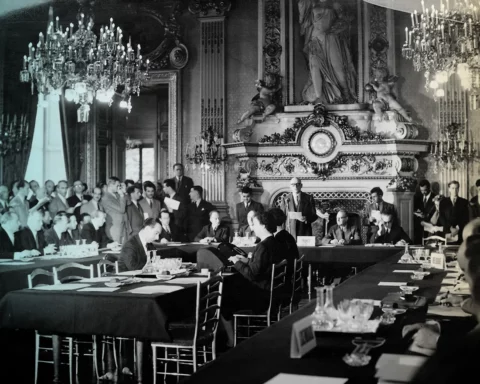
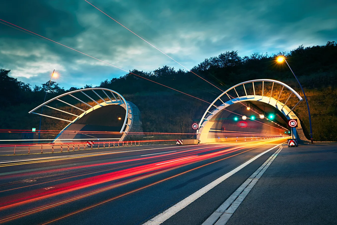
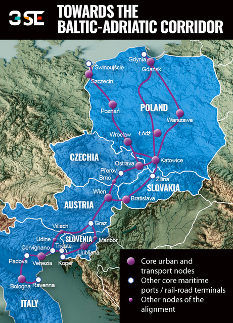
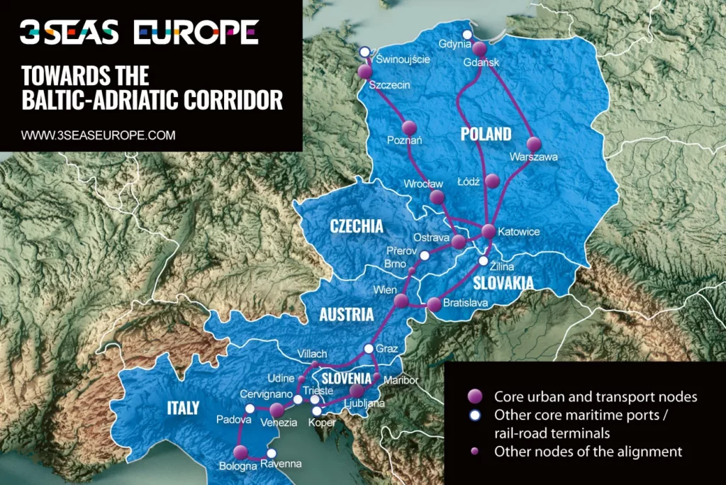
Work is now underway to make this one of the most important roads on the ‘secret map of Europe’ fully passable. This is being done through the “Baltic-Adriatic Corridor,” a project co-financed by the European Union. The idea is to connect the Baltic seaports of Gdańsk, Gdynia, Szczecin, and Świnoujście in the north to the Adriatic ports of Koper, Trieste, Venice, and Ravenna in the south. When will it be completed?
Henry Ford’s method
1882 km – this is the distance between Gdynia and Ancona, the opposite ends of the “Baltic-Adriatic Corridor.” But enclosing them with transport infrastructure will require paving and track laying over a much longer distance. The road connections in this corridor alone will total 3795 km. All because it involves roads running (at least partly) parallel to each other in many sections. Looking at a map, this corridor looks less like a level road and more like a spider web of densely woven sections intersecting each other at different angles. A real backbone.
In addition, this backbone has its mirror image, which is a train connection. What’s more, the tracks are even longer than the roads, as between Gdynia and Ancona, they stretch a total of 4472 km. It is intended that up to 740-meter-long trains will run on them (a typical high-speed train is no longer than 350 meters). The minimum line speed for passenger lines is expected to be 160km/h. The entire system will be equipped with a unified European Rail Traffic Management System (ERTMS).
And that’s not all. The project also covers seaports, at least two airports (in Warsaw and Vienna), as well as 26 rail-road terminals. Full multimodality.
So how will such a huge, complex project come to fruition? Using Henry Ford’s method. “Nothing is particularly hard if you divide into small jobs,” the American entrepreneur once said. The implementation of the “Baltic-Adriatic Corridor” has been divided into half a thousand “small jobs.” The European Commission identified exactly 492 different projects, which, combined together, will achieve the goal.
The total budget? It is estimated at EUR 87.8 billion. Nearly half of this sum is related to rail and ERTMS initiatives, which correspond to over 150 projects. One hundred sixteen different road transport projects account for 25% of the total budget, and maritime measures are responsible for 18% of all expenditures spread across 123 initiatives. This is how Henry Ford’s method looks in practice.
Heading towards a Renaissance 2.0
According to the assumptions, the basic version of this massive corridor is to be completed by 2030 and the extended version by 2040. It crosses six countries (Poland, Czech Republic, Slovakia, Austria, Slovenia, Italy) and interconnects the urban nodes of Szczecin, Gdańsk, Poznań, Wrocław, Łódź, Warszawa, Katowice, Kraków, Ostrava, Bratislava, Wien, Venezia, Bologna, and Ljubljana.
These projects are at least written down on paper. In practice – as is usually the case with infrastructure investments – the picture is less rosy. The European Union helped finance 123 projects with a total budget of EUR 2.54 billion through the Connecting Europe Facility mechanism. Until mid-2021, only 40% of all projects had secured financing.
“It has become evident that project implementation is affected by low financial and technical project maturity. Delays due to the spread and persistence of the Covid-19 pandemic add to already lengthy planning procedures, adversely affecting the timely realization of projects. This is an issue which could be even more critical for cross-border projects,” wrote Anne Elisabet Jensen in mid-2022 on behalf of the European Commission, with whom she is coordinating the development of “The Baltic-Adriatic Corridor.”
Roadblocks ahead
First pandemic, later the war in Ukraine – all these crises make it even more difficult to follow with infrastructure investments. For instance, right now, not even 20% of the road corridor infrastructure complies with the corridor’s requirements. But in the long term, it is the development of such infrastructure that is the best way to avoid further armed conflicts.
“When goods do not cross borders, soldiers will,” once said Frederic Bastiat, a 19th-century French intellectual. The dense network of connections reinforces the interdependence between countries, making it easier for them to meet the challenges of the modern age. Central Europe, which has long lagged behind other parts of the continent in this respect, is finally getting a real chance to level the playing field. And all the more so as, independently of the “Baltic-Adriatic Corridor,” the Via Carpatia connecting Klaipeda in Lithuania to Thessaloniki in Greece is under construction.
Of course, one should not praise the day before the sun sets and the roads before they are completed – but if both of these projects can be finalized, the CEE countries will suddenly benefit from a complete transportation infrastructure. This “secret map of Europe,” described at the beginning of this article, will become visible once again. And it is not at all unlikely that this will be the moment when we start talking about a Renaissance 2.0 in Europe.